Unveiling Nature Coast: A Paradise for Travelers
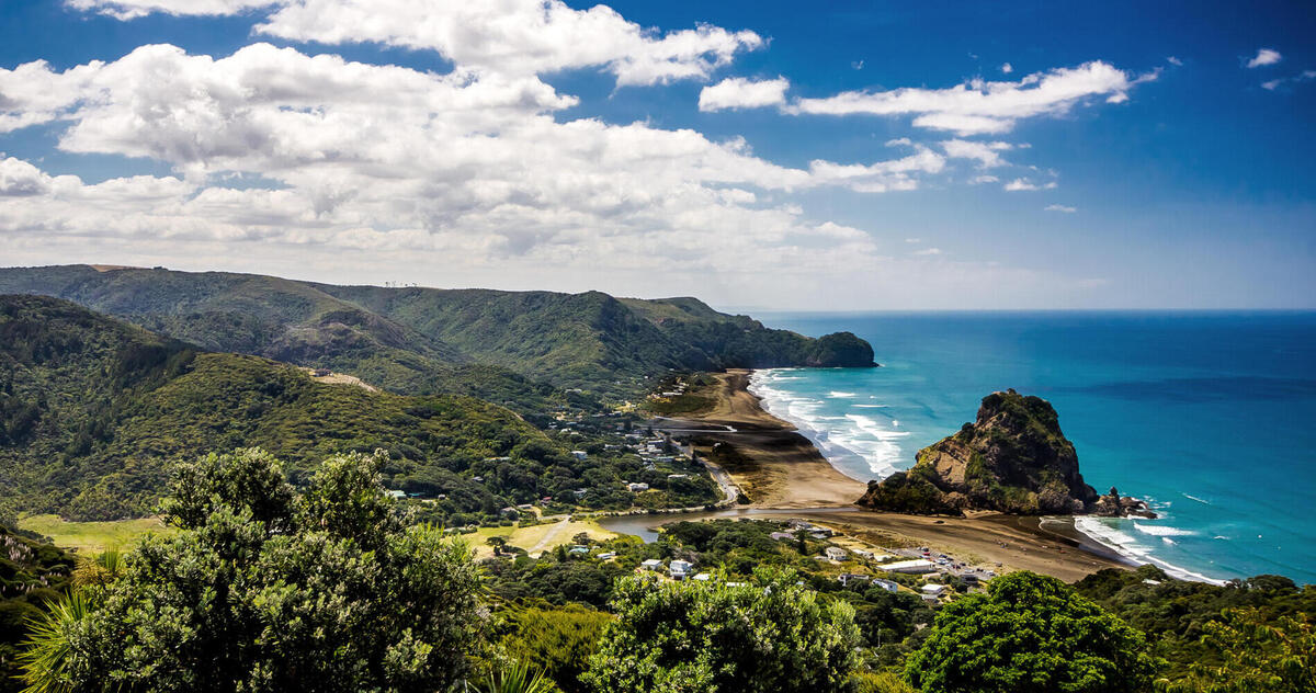
Welcome to Nature Coast, a captivating region nestled between the lush landscapes of Kapiti and Horowhenua. Renowned for its stunning natural beauty, diverse wildlife, and rich cultural heritage, Nature Coast is the ultimate destination for travelers seeking adventure, relaxation, and inspiration. Whether you’re here to explore serene beaches, majestic forests, or vibrant local communities, Nature Coast offers something special for everyone.
Visitors can indulge in activities ranging from leisurely coastal strolls to thrilling outdoor adventures. The region’s unique blend of natural wonders, historic landmarks, and friendly locals ensures an unforgettable experience for every type of traveler.
Discover the Beauty of Kapiti and Horowhenua
Nature Coast spans the breathtaking Kapiti Coast and the charming Horowhenua District, each boasting unique attractions and experiences. From the pristine shores of Kapiti Island, a renowned bird sanctuary, to the rolling farmlands and artisanal markets of Horowhenua, every corner of this region invites exploration.
Kapiti Coast: This coastal gem is known for its golden beaches, vibrant marine life, and outdoor activities. Visitors can enjoy fishing, kayaking, or simply soaking up the sun. The Kapiti Marine Reserve also offers opportunities for snorkeling and diving, showcasing the region’s underwater biodiversity. Whether you’re visiting in summer for water adventures or winter for peaceful coastal escapes, knowing the best times to visit Kapiti Island can help you make the most of your trip.
Horowhenua District: A haven for agricultural tourism, Horowhenua invites visitors to experience its lush farmlands, orchards, and bustling farmers’ markets. Savor fresh produce, discover handmade crafts, and take part in seasonal festivals that celebrate the area’s rich farming heritage.
Take a scenic drive through lush countryside, savor fresh local produce, and immerse yourself in the warm hospitality of our communities.
Top Attractions
Nature Coast is home to a wealth of must-see attractions that showcase the region’s natural and cultural treasures.
- Kapiti Island: A sanctuary for native birds and a haven for nature lovers, offering guided tours and stunning panoramic views. Experience the thrill of spotting rare species such as the Takahe and Little Spotted Kiwi, and learn about the island’s significant role in conservation efforts.
- Nikau Reserve: A tranquil escape into New Zealand’s iconic native bush, with well-marked walking tracks suitable for all ages. The reserve is a favorite spot for birdwatchers, with species like the Tui and Bellbird frequently making appearances. However, visitors should be mindful of how changing weather affects hiking trails, as rain or extreme heat can influence trail accessibility.
- Foxton De Molen Windmill: A symbol of the region’s Dutch heritage, this fully operational windmill offers a glimpse into traditional milling practices. Visitors can climb to the top for spectacular views and purchase fresh, locally milled flour from the on-site shop.
- Local Beaches: From the golden sands of Waikanae to the surf-friendly shores of Paraparaumu, the coastline is perfect for swimming, sunbathing, and water sports. The beaches are also ideal for leisurely walks, picnics, and capturing breathtaking sunsets.
Each attraction offers a unique way to connect with Nature Coast’s rich landscape and history.
Plan Your Visit
Make the most of your Nature Coast adventure by planning ahead. Start by exploring our comprehensive Visitor Information section, where you’ll find details on i-SITE Visitor Centres, accommodation options, and travel tips.
For outdoor enthusiasts, the Walks & Tracks section highlights the best hiking trails, from easy family-friendly walks to challenging treks offering panoramic views. Nature lovers can discover hidden gems and learn about the flora and fauna unique to the region.
Business travelers or those interested in the local economy can explore the Business & Enterprise section to learn about regional opportunities and networking events.
Whether you’re exploring for a day or staying for the week, these featured articles will help you prepare, stay safe, and experience the best of Nature Coast.
Featured Reads for Your Trip:
How Changing Weather Conditions Impact Your Experience at Nature Coast Attractions
Learn how different weather patterns affect outdoor plans, wildlife tours, and beach days—and get tips on how to adapt your itinerary.
Best Times to Visit Nature Coast: Plan Your Trip Around Key Events
Find out which seasons offer the best experiences for events, nature watching, and crowd-free travel. Perfect for planning around the calendar.
What to Pack for a Trip to Nature Coast
Not sure what to bring? This guide breaks down essential items for every season, so you’re never caught unprepared.
Budget-Friendly Activities on Nature Coast
Explore a range of low-cost experiences, from scenic walks to cultural gems, all without straining your travel budget.
The Importance of Time Management When Exploring Nature Coast Attractions
Make the most of your visit by learning how to structure your days around top attractions and limited-time experiences.